

The Grand Canyon
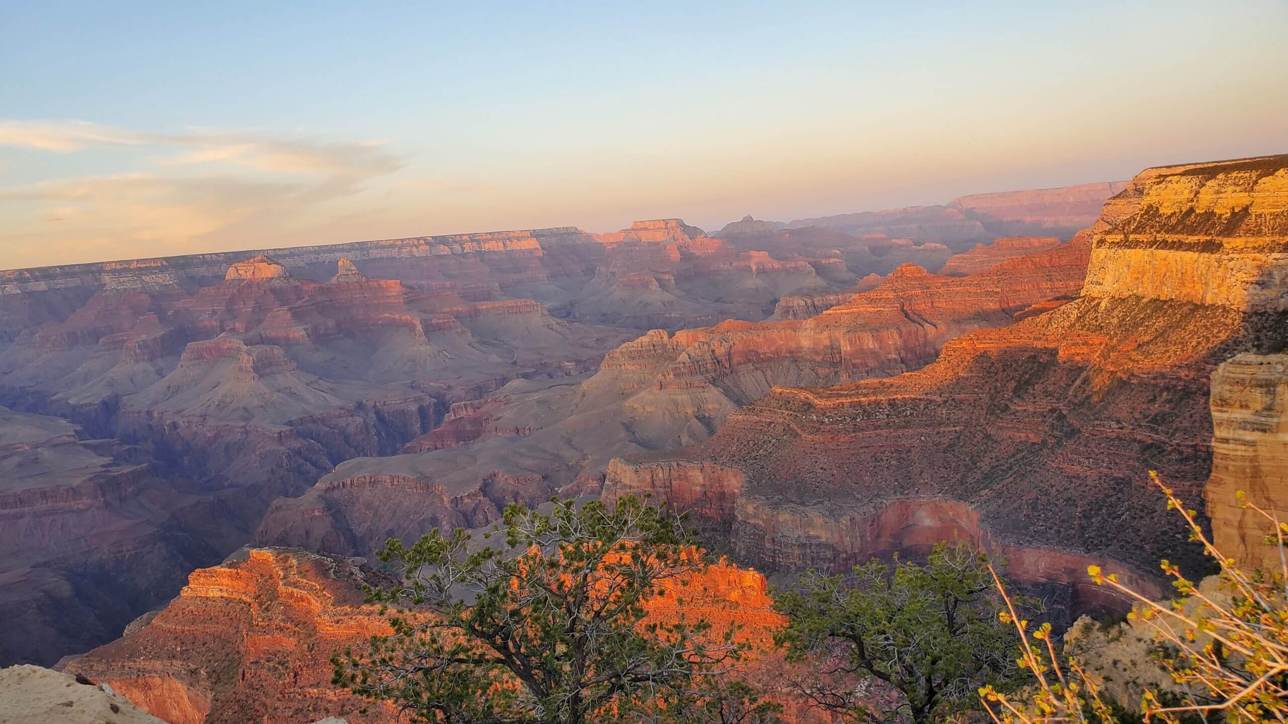
Photo: The Grand Canyon South Rim, Arizona
The Grand Canyon, a geological wonder and natural masterpiece, does not fail to evoke awe with its beauty, size and history, in just about anyone who sets eyes on it. Home to native American tribes who have lived here for thousands of years, and a heaven for adventurers, spiritualists and artists.
See no pins? Please move map left-right-up-down until you see them. Zoom in and out for pins to separate. Use the Share icon on top right corner of the map to send it to your phone or email.
(A) Flagstaff (B) Grand Canyon South Rim visitor center
The above map shows driving directions from Flagstaff to the Grand Canyon South Entrance. Also on the map, note points of interest (click blue pins) like Havasu Falls (labeled as Supai), Grand Canyon North Entrance, Grand Canyon West which are all described in this blog.
The map shows other points of interest that we have covered on our visits to Arizona. Time permitting, you could visit. I will be writing a blog in the future to cover those as well.
What’s on this page?
-
- Tidbits
- Highlights (use it to build your own itinerary)
- Trip Experience of the Rim to River Hike (Personal experience narrative)
- Vegetarian/Vegan Food
- Free Subscribe
- Comments
Contributor Credits
Thanks to Bala Ekambaram, Dallas, TX, for writing the narrative section, summarizing his preparation and the hike to the bottom of the canyon with his son. My own visits to the South Rim and North Rim, combined with reading up on the West Rim, enabled me to write the Highlights section and add all pictures prior to his narrative.
Pictures and the descriptions starting from the Highlights section are from our visit to the Grand Canyon in the early 2000 and once again in May 2022.
— Jyothi
Tidbits


Know the Essentials
How best to get around? With The Grand Canyon being one of the 7 natural wonders of the world, it has tourists from all over the world. People visit the Grand Canyon by driving in, by tour buses and RVs typically. There is no public transport to bring you into the park. There is a historic railway from the city of Williams, AZ (near Flagstaff, AZ) that takes you to the Canyon. The train is not an average commuter train but a vintage one with entertainment onboard. The Grand Canyon is a national park managed by the national park service and has a visitor center that will be your first point of interest in order to find out more about park activities, weather, maps and everything you need to know from the helpful rangers. Also, it is a good experience to stay inside the park than outside of it, if your budget allows for it. You will be able to utilize time better as well. There are park lodges like the Yavapai lodge. The El Tovar Hotel is an iconic one which gives great views of the canyon.
Currency is the US Dollar. Can easily use credit cards everywhere as long as you are aware of any foreign transaction fees charged by your credit card company, if you are travelling to the US from elsewhere.
Power outlets in the US are either A or B type plug adaptres with 110 V and 60Hz.
The weather is extremely hot and sunny in summers, cold in the winters. Best time to visit is March through May and September thru November. Check out more details on weather and events.
There cannot be enough said about dangers and safety when it comes to hikers. There are warnings posted everywhere in the park for hikers to not attempt strenuous trails without being properly equipped and also not attempt doing the rim to canyon or rim to rim hikes in one day. One needs to pay full heed to these warnings and to not become a liability or part of an undesirable statistic. Each year rangers rescue people who are dehydrated, passed-out and sick on trails. We also see news items where fit and experienced hikers have died when attempting to do strenuous trails in a day, especially in the scorching heat. The other warning, kindly do not go near wildlife. With this in mind, these parks are meant to be sensibly enjoyed.

Highlights
Rims and Hikes
Are you a Grand Canyon visitor who wants to see the epic views using the park transportation system? Or you would like to try a few trails from easy to hard? Whichever kind of a visitor you are, you will find information in the section below.
Here is a great resource for maps, Grand Canyon Maps | NPMaps.com


Highlights (+ to open, - to close)
The South Rim, altitude 7000 ft above sea level
The south rim is more developed and offers many restaurants and experiences. There is a shuttle bus service that takes you to several viewing points. The red route that takes you all the way to Hermit’s Rest has some wonderful viewpoints with the Hopi point known as best to enjoy sunsets. When waiting for the shuttle after sunset we didn’t realize how quickly the temperature dropped! We were cold in May.
Other than the shuttle route, view points like Mather point, Desert view and Yaki point are great vantage points for viewing the mega canyons and their spread.
-
Rim Trail
A paved, flat and easy 13 mile walk (4 to 5 hours long) on the top of the rim, stretching from the South Kaibab trailhead to Hermit’s rest. It pretty much allows you to board the shuttle along the way if you want to do so. A great resource for the Rim Trail.
South Rim pictures below
Throwback from our visit in 2000 with the 3-year-old, and revisit to the South Rim in 2022 with the same kid, all grown-up :-). Did we also notice in difference in photography? 😉


The North Rim, 8300 ft above sea level
North Rim is only accessible during the summer months, usually from mid-May to mid-October, due to heavy snowfall during the winter. We visited the North rim in 2022. We saw several patches of snow on the ground still in May. In my opinion, the north rim is not as dramatic as the South rim with respect to color and the feeling of vastness but it is lovely, nevertheless with less crowds and more peace.
Some experienced hikers go the bottom of the canyon from this rim as well as there is a trail. Whether from the South rim or the North, do not attempt to hike down and come back up the same day even if you think you are very fit.
-
North Kaibab Trail
The North Kaibab Trail is a challenging 15-mile-long trail to the Colorado river and descends 6000 feet to the bottom of the canyon. Popular stopping points along the trail include Coconino Overlook, Supai Tunnel, Roaring Springs, and the Cottonwood Campground.
Details of many other challenging and easy hikes can be found in this great resource for hike descriptions, lengths and times.
-
Easy Trails of the North Rim
Bright Angel Point Trail
This is a short, paved trail that leads to Bright Angel Point, offering panoramic views of the canyon. It’s an easy hike and one can also visit the Grand Canyon Lodge.
Cape Royal Trail
A short and easy hike that takes you to the Cape Royal viewpoint.
Point Imperial Trail
Point Imperial is the highest point on the North Rim and offers breathtaking views of the eastern Grand Canyon and the Painted Desert. The trail to Point Imperial is short and suitable for most hikers.


The West Rim offers just two hiking trails, one easy and one moderate, and neither one goes into the canyon.
This region is owned and operated by the Hualapai Indians.
It is less crowded, and it is home to the skywalk which offers pricey but spectacular views of the canyon by standing right over it and gazing down!
Information about the skywalk and tickets here. This rim is also closest to Las Vegas (3 hour drive).
Epic Challenging Hikes of the Grand Canyon
The Rim to River Hike is from the South Rim which is at an elevation of 7000 ft above sea level.
Read the narrative section in this blog for a first-hand account about the hike experience.
Considered a very strenuous hike, one needs to train, and be very well-prepared. Read this very helpful article to know more and who should even attempt this hike. It is a great article by ‘the hiking guy’ with lots of minute details, maps and images, about the hike and gear.
There are warnings everywhere about not trying to attempt the hike down and back up on the same day and it is up to us to exercise judgement and caution. There is not always a mule option and ranger rescues can take hours if you have an emergency.
It is recommended to start at South Kaibab Trail (no water resource, you have to carry), and then ascend back to the South Rim on the Bright Angel Trail (has some water resources).
South Kaibab Trail
Very challenging, steep, less shade and dramatic views. The trail begins on the South Rim near Yaki Point and descends to the Colorado River. Elevation change from rim to river is 4860 ft (1480 m), trail is 6.3 miles long.
Spend at least a night at the Phantom ranch or Bright Angel campground before heading back up. The trail back up takes twice as long. These reservations need to be made a year in advance through the National Park Service/Xanterra for Phantom ranch, and you can book four months in advance for the back-country permit to camp. Details on booking can be found in this article (Article is about the rim-to-rim hike but overnight stay information is the same).
Bright Angel Trail
The trail begins on the South Rim near Kold Studio and descends to the Colorado River. Elevation change from rim to river is 4460 ft (1360 m), and trail length is about 9 miles. This trail passes through Havasupai Gardens.
This is a must-read article that shows the distances from point to point.
Read the narrative section in this page for a firsthand account and a day-by-day plan for the rim to river hike.
The rim-to-rim hike is about 24 miles long and considered very strenuous. It takes you from the north rim to the south rim, or vice-versa.
The North Kaibab trailhead to the river is 15 miles long that of takes you to the bottom the canyon.
Coming back up the Bright Angel trail is about 9 miles long as mentioned before. Please read in detail about the rim-to-rim hike.
Official time stated to do this is 5 to 6 hours but it really takes much longer. Offers some shade along the way. This is a very challenging hike and as per the National Park Service, it generates the most rescues and 911 calls in the year! You can go part way and head back if you don’t want to go all the way down.
This is a must-read article that shows the distances from point to point.
The North Rim, 8300 ft above sea level
The South Rim, 7000 ft above sea level
The below hikes are from the South Rim
- Hermit Trail, Grandview Trail
- Tanner Trail.
Both steep to very steep, ranging in distance from 2.2 miles to 7 miles in challenging terrain.
Between the South Rim and Grand Canyon West
One Grand Canyon hike to consider doing is the 10-mile (each way) track to Havasupi Falls (it is also called Havasu Falls) located on Native American land, Supai Indian Reservation.
Currently, you are required to stay for a minimum of 3 nights/4 days, either by camping or at the lodge. Link to make reservations: Havasupai Reservation system.
Reservations/Permits are required much ahead of time and limited.
Everything You Need to Know About Havasupai Permits 2023 (dothecanyon.com)
Read this to know more. Everything You Need to Know About Havasupai Permits 2023 (dothecanyon.com)


South Rim


North Rim


Havasupi Reservation/Havasu Falls Hike


Trip Experience of the Rim to River Hike (Level: Hard)


This Trip Experience section is for those who intend this intense hike. If you are not one of those and are a casual Grand Canyon visitor or want to stick to easier trails, you will find information in the Highlights section.
Day-by-Day Rim to River Hike
Thanks to Bala Ekambaram who did the hike down to the Canyon floor with his son, Vik in Nov 2017 and wrote this feature with their pictures for my blog.
In 1963, Bob Dylan recited, as his role model and inspiration, Woody Guthrie, lay dying, “To find hope, you visit him at the Brooklyn Hospital; to find God, you go to the church of your choice”. You will find both in Grand Canyon at sundown.
These are profound words repeated by Bala who writes this feature on the Grand Canyon and takes you on a hike from the top to the bottom of the canyon. Scroll down!! Not many do this hike and I urge you to read and get inspired get some great preparation tips into hiking the South Kaibab trail or Bright Angel trail if your fitness allows it.
Backpacking in the Grand Canyon: South Kaibab Trail, Bright Angel Trail
To test the surmise by Bob Dylan mentioned above, my son, Vikram, and I embarked on a 5-day backpacking adventure. It was grueling – going down 7000 feet was optional, the sign warned, but up was mandatory! During the trip, we cursed. We teased. We whined. We questioned our judgment. We laughed. We yelled. We joked. We compromised. We listened. We discovered a little of ourselves. But mostly we talked.
For the intrepid adventurer who wants to try this out, I have 2 pieces of advice (a) time your trip during the shoulder seasons. We went in November, and although the rim was cold, the temperatures rose to a perfect 60-65 F at the bottom (b) be mentally prepared for the arduous and tiring backpack-laden hike up. You will see a lot of warnings about taking enough water with you – which is all true, and you should respect them…but don’t get too nervous about it. November is nice, and if you stay in the main corridor trails and campgrounds, there are places to fill up.
Planning and preparation
Google, and you will find plenty of information on tips, tricks, hiking maps, itinerary suggestions, attractions, lodges, etc. Our itinerary was within the “main corridor” – I had read many stories about people getting lost, or dying of thirst, that I prioritized safety over everything else.
-
-
- Day 0 – arrive in Phoenix, drive to GC, and stay overnight at Bright Angel Lodge, Southern Rim, inside the park
- Day 1 – hike down the South Kaibab Trail to the bottom of the canyon (6 hours)
- Day 2 – hang around at the bottom of the canyon, camp 2 nights at Bright Angel Campground
- Day 3 – hike up a few miles, camp at Indian Garden Campground (5-6 hours)
- Day 4 – hike up to the Southern Rim (5-6 hours), drive to Phoenix, stay in a hotel
- Day 5 – fly out of Phoenix late in the morning
-
You need to decide your itinerary so you can make campground reservations + get the backcountry permit through NPS website months in advance. For backpacking gear list, download the checklist from REI site. You have to stop by an REI location in Phoenix to pick up cooking fuel for camping, because you cannot bring them in the flight.


Day 0 – Southern Rim, Bala and Vik high-spirited and ready!
Day 0 – Arrival to the Southern Rim
We got into the park late in the afternoon. We did the touristy thing of walking around the Southern Rim lookouts. The views were grand. You feel humbled. It is awe inspiring. Vikram and I monkeyed around taking pictures and ate dinner at the lodge. Surprisingly good food, like, it is a nice sit-down restaurant.We stayed at the Bright Angel Lodge. The night froze dropping to 26 F. I was worried – was it going to be like this all through? The room was basic, nothing to write home about. And boy, did we crank up the heat that night.
Day 1 – Southern Rim to Bright Angel Campground (bottom of the canyon) – about 6 hours
In the morning, we jumped into the public service bus that stopped at the lodge, and which took us to the South Kaibab trailhead. There is no grand sign, a big entrance, or a brass band to greet us! It just began. Walking briskly helped us manage the cold, but we did wear a jacket, and a winter hat. Light gloves would have helped, but we didn’t bring any.
In less than a hour, we hit the Ooh Aah Point, and we got the first panoramic view of the canyon. Take a close look at the picture, and you will notice the river snaking at the bottom of the gorge.From here, we hiked to Cedar Ridge. We don’t see much vegetation except desert shrub such as creosote bush, ocotillo, sagebrush, and blackbrush. Funnily enough, we didn’t see any Cacti. Go figure.We got to Skeleton Point, where we rested a bit, had lunch, basked in the sun. It was super dusty here. In the next 3 hours, we rapidly hiked down through the limestone cliffs, where the trail has been literally blasted through, in a series of switchbacks and we got a dramatic sense of exposure to the mountains around us. Down at the bottom, we use the Black bridge to cross the Colorado river, and get to the Bright Angel Campground.

Day 1: South Kaibab Trail, Cedar Ridge

Day 1: Ooh Aah Point

Day 1 – South Kaibab Trail, Skeleton Point

Day 1 – South Kaibab Trail – Black Bridge

Day 2 – Bright Angel Campground, Phantom Ranch
The Bright Angel Campground is well equipped with toilets and drinking water. The camp sites are clean, and well paved. There is a creek running right by. Weather was a perfect 60-65 F, though night was cool and we slept with our jackets on.
During the day, we left our backpacks in the tent, and hiked around to the famed Phantom Ranch. It is not a terrible idea, if you are able to plan that far ahead, and lucky to get reservations, to book a room at the Phantom Ranch. Instead of camping, one could stay at the lodge, get a clean shower, and a good night’s sleep.
We hiked on a couple of small trails around. It was green, with a lot of vegetation such as coyote willow, arrow weed, seep willow, and mesquite. As the day got warmer, we walked over to the beach next to the river. The water was cold and refreshing and watching the ring of towering mountains was beautiful. As the sun sank behind them, twilight quickly fell upon us, and we headed back to the campground.


Day 2 – Bright Angel Campground Morning Silhouette

Day 3: Start of hike

Day 3 – Hiking up from Bright Angel to Indian Garden Campground
The Indian Garden Campground is about halfway to the top (Southern Rim). Right off the bat, as soon as we crossed the river, we saw steep ascents. We were now hiking back via the Bright Angel trail. Similar to the South Kaibab Trail, it was mountainous. However, vegetation was plentiful and different – we saw a lot of pinyon pines, and Utah junipers. We waved a couple of mule trains carrying people and supplies up the trail.We saw a couple of plunge pools and small waterfalls where the Garden Creek flowed into the Pipe Creek drainage. And then, we hit the Devil’s Corkscrew. This is a horrific series of switchbacks that wound its way through the dark cliffs of, we were told, the 2-billion-year-old Vishnu Schist, the oldest rock in the Grand Canyon. We climbed 500 feet in about ½ mile – that was some elevation gain, and each step was a chore. We pushed ourselves and encouraged each other to keep the pace.
We reached Indian Garden campground in the early afternoon, and we were pooped. We took our time setting up tent – there weren’t too many people around, so we could have our pick of campsite.

Day 3: Rest on our backs
Day 4 – Indian Campground CG to the Southern Rim
This was the last day, and the home stretch, and that gave us the extra energy. We started off on a gentle slope and saw many cottonwood trees. Our joy was short-lived. We enjoyed the Redwall Limestone and then encountered Jacob’s Ladder, a series of switchbacks. But the views were beautiful, and we looked forward to every turn. We stopped at the Three-Mile Rest House to rest a bit, fill our water.
As we climbed the next series of switchbacks, we started seeing more people, families – these were day hikers, all well dressed and clean, and they must have been wondering who these 2 dusty raggedy unshaven creatures were from. The vegetation started turning into tall Ponderosa Pines, and soon we were at the 1½-Mile Rest House, and I want to say there were people milling around!
The winds of anticipation were pushing our sails, and the last mile was quick. We started to see more limestone rock that is characteristic of the trailhead. We stopped at the Bright Angel Pass and have someone take a picture of us. This was before COVID! It was early afternoon when we were back at the Southern Rim.

Vegetarian/Vegan Food
For suggestions on how to manage as a vegetaria, and options one has when visiting national parks, go to National Parks in the US: How to manage as a vegetarian
Free Subscribe
If you have liked this page, here is a request from me to support the hard work! Thanks, it’s much appreciated!
- Leave a comment on this page (scroll down), share your own experiences if you have already been to this place.
- Subscribe to travelstosavour and receive 2 free blog posts per month, featuring 2 new destinations (scroll down to the footer to subscribe).
- Follow travelstosavour on social media – Facebook, Instagram and Youtube (by a click of the button in the footer) and share all the goodies with your pals!
Check out other destinations and nature escapes on this site.
Great blog and lovely pics with lots of very pertinent details. Helped me decide on when to attempt and which trail to attempt – hope to attempt the North Kaibab trail maybe in March!
Cool!! Great to know you could use it. Let me know after you do the trip. Thanks for checking my site out.